In the world of trackless ride systems, the debate of lidar vs magnetic navigation trackless ride centers on accuracy and cost. Lidar navigation offers advanced mapping and obstacle detection, which delivers high precision in dynamic environments. Magnetic navigation provides reliable guidance with lower installation costs, especially in established indoor spaces. Operators must evaluate which system matches their ride goals, operational environment, and long-term investment strategy.
Key Takeaways
- Lidar navigation offers high accuracy and flexibility, making it ideal for dynamic environments that require frequent layout changes.
- Magnetic navigation is cost-effective and reliable for fixed-path rides, requiring minimal maintenance and providing consistent performance.
- Operators should regularly calibrate and maintain both lidar and magnetic systems to ensure optimal accuracy and reliability.
- Choosing the right navigation system depends on the ride's operational needs, budget, and future scalability requirements.
- Hybrid navigation systems that combine lidar and magnetic technologies can enhance reliability and adaptability in trackless ride environments.
Navigation Technologies in Trackless Ride Systems
Lidar Navigation Overview
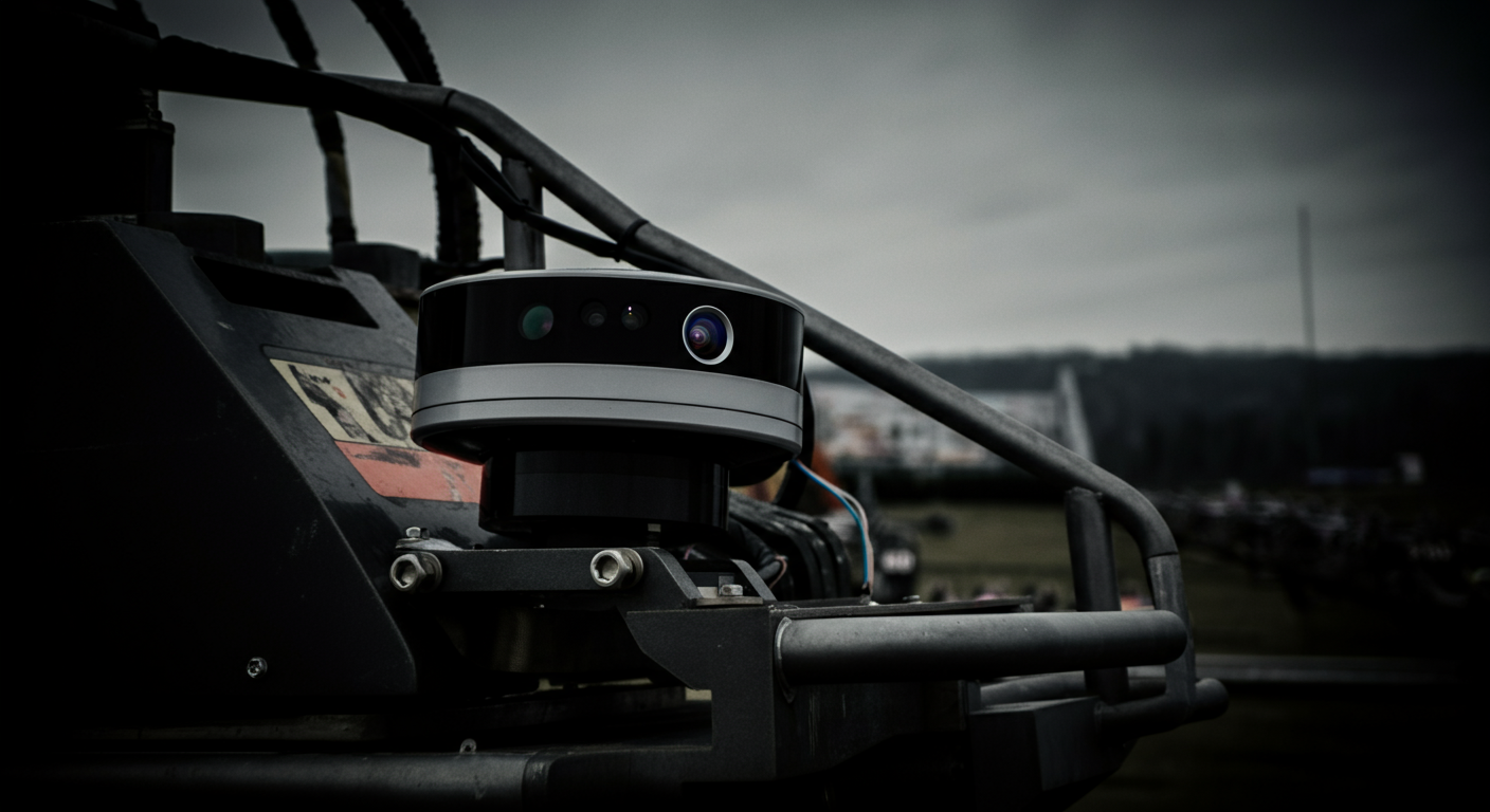
Lidar has become a core technology in modern trackless ride systems. This navigation system uses a lidar scanner to emit laser pulses, which bounce off surrounding objects and return to the sensor. The system measures the time it takes for each pulse to return, creating a detailed map of the environment. Lidar-based techniques enable precise localization, allowing vehicles to navigate complex layouts and avoid obstacles. Most automated vehicles combine lidar with other sensors, such as inertial measurement units and optical encoders, to improve localization accuracy. Sensor fusion is essential for maintaining reliable localization, especially in dynamic environments. Lidar scanners also support real-time updates to the localization system, which is critical for safety and smooth operation. Lidar-based techniques often work with RFID tags embedded in the floor to correct any drift in localization. This fusion of technologies ensures the agv navigation system remains robust and accurate.
Magnetic Navigation Overview
Magnetic navigation offers a different approach to localization in trackless rides. The system relies on adhesive magnetic tape placed on the ground. Vehicles detect the tape using onboard sensors, following the designated path with high reliability. This navigation system is known for its simplicity and safety. If a vehicle strays from the tape, it can stop immediately, reducing safety risks. Adjusting the path is straightforward—operators only need to reposition the tape. Magnetic navigation systems require minimal maintenance and are resilient to changes in lighting or minor obstacles. This makes them a popular choice for environments where safety and operational stability are priorities.
Integration in Automated Guided Vehicles
Automated guided vehicles (AGVs), also known as trackless ride AGVs, serve as the backbone of many modern ride systems. These vehicles integrate advanced localization systems, combining lidar scanners, magnetic sensors, and sensor fusion algorithms. The localization system coordinates vehicle movement, ensuring precise navigation and safety. AGVs often use a combination of lidar-based techniques and magnetic navigation to enhance flexibility and reliability. The fusion of multiple localization methods allows the system to adapt to different ride layouts and operational requirements. In high-profile attractions like Star Wars: Rise of the Resistance, AGVs use a blend of navigation technologies, including lidar, RFID, and local positioning systems, to deliver immersive and safe experiences.
Note: Additional navigation technologies, such as WiFi, RFID, and local positioning systems, are often integrated to further enhance localization and storytelling in trackless ride environments.
Lidar vs Magnetic Navigation Trackless Ride: Accuracy
Lidar Accuracy
Lidar has transformed the landscape of localization in trackless ride systems. The lidar scanner emits rapid laser pulses, mapping the environment with high density and detail. Lidar-based techniques enable vehicles to detect obstacles, adjust routes, and maintain precise localization. However, recent comparative studies reveal that lidar methods can show mediocre results in the short term, sometimes producing higher error values than expected. The quality of the environmental map plays a critical role in determining the final accuracy of lidar-based techniques. If the map lacks detail or contains errors, the localization system may struggle to maintain consistent accuracy.
Several factors influence the accuracy of lidar in both indoor and outdoor environments. The following table summarizes the most significant variables:
| Factor | Description |
|---|---|
| Sensor hardware and calibration | Calibration drift can introduce errors; regular calibration is essential for accuracy. |
| Environmental conditions | Bright sunlight, shiny surfaces, fog, dust, or rain can distort the return signal, affecting accuracy. |
| Scan range and angular resolution | Increased distance from the scanner to the surface raises the margin of error; angular resolution affects point density. |
| GNSS and IMU integration | Essential for tracking the scanner's position and orientation in mobile and aerial systems. |
| Data processing and post-processing | Raw data needs significant processing to create usable 3D models, impacting final accuracy. |
| Mechanical stability during capture | Movement and vibrations during capture can distort the scan, leading to inaccuracies. |
Lidar-based techniques require careful calibration and regular maintenance to ensure optimal performance. The localization system must process large volumes of data from the lidar scanner, which can introduce delays or errors if not managed properly. In dynamic environments, the ability of lidar to update maps in real time supports high accuracy, but only when environmental conditions remain stable.
Magnetic Navigation Precision
Magnetic navigation offers a different approach to localization. This system uses magnetic tape or markers embedded in the floor, which the vehicle’s sensors detect and follow. The localization system in magnetic navigation relies on the physical presence of the tape, making it less susceptible to visual or lighting changes. Precision remains high as long as the tape is intact and free from interference.
Magnetic navigation excels in environments where the path remains fixed and predictable. The localization system can quickly detect deviations from the tape, allowing for immediate corrective actions. This approach reduces the risk of navigation errors and supports consistent accuracy over time. However, the system’s precision can be compromised by strong magnetic fields or nearby metallic objects, which may disrupt sensor readings.
Environmental Impact on Accuracy
Environmental factors play a significant role in the accuracy of both lidar and magnetic navigation systems. The following points highlight key environmental impacts:
- Temperature Effects: High temperatures can cause lidar components to overheat, reducing efficiency and affecting the accuracy of the localization system. Low temperatures may slow mechanical parts, impacting navigation performance.
- Humidity Impact: Excessive humidity can lead to damp electronic components, increasing the risk of short circuits and malfunctions in both lidar and magnetic navigation systems.
- Magnetic Interference: Large metallic objects or underground infrastructure can disrupt magnetic sensor readings, leading to reduced accuracy in magnetic navigation.
- Calibration Needs: Both lidar and magnetic sensors require regular calibration, especially in environments with fluctuating magnetic fields or high electromagnetic noise.
Tip: Regular maintenance and calibration of the localization system help mitigate many environmental impacts, ensuring reliable accuracy for both lidar and magnetic navigation trackless ride systems.
Cost Analysis for Trackless Ride Navigation
Installation Costs
The initial investment for a trackless ride navigation system depends on the chosen technology. LiDAR-based techniques require advanced sensors, a lidar scanner, and integration with the localization system. This setup often involves higher upfront costs due to the need for precise calibration and robust data processing hardware. In contrast, magnetic navigation uses adhesive tape or embedded markers, which lowers installation expenses. Operators can quickly lay magnetic tape along the desired path, making the process efficient and less disruptive to existing infrastructure. However, the simplicity of magnetic systems may limit flexibility if future layout changes are needed.
Maintenance and Operational Costs
Maintenance plays a critical role in the long-term performance and cost-effectiveness of automated ride systems. Magnetic navigation systems require periodic tape replacement every 18–36 months. These systems are sensitive to floor vibrations, which can increase maintenance frequency and costs. LiDAR-based techniques, on the other hand, do not rely on consumables. The main requirements involve firmware updates and occasional sensor recalibration. This results in lower operational costs over time and less downtime for the ride. The table below summarizes the maintenance differences:
| Navigation Type | Maintenance Requirements | Cost Implications |
|---|---|---|
| Magnetic Navigation | Tape replacement every 18–36 months; sensitive to floor vibrations | Higher maintenance sensitivity and costs |
| LiDAR Navigation | No consumables; only firmware updates required | Lower operational costs over time |
Hidden and Long-Term Expenses
Operators must consider hidden and long-term expenses when evaluating the cost-effectiveness of a navigation system. Energy consumption can vary between electric drivetrains, impacting operational budgets. Preventive maintenance labor increases for systems that require frequent recalibration, such as those using magnetic tape. Part availability and lead times for custom components may cause extended downtime, affecting ride performance and safety. Software licensing fees and specialized staff training also contribute to ongoing costs. LiDAR-based techniques, with fewer consumables and lower maintenance sensitivity, often provide a more cost-effective solution for automated trackless ride systems focused on high accuracy and performance.
Tip: Regularly review maintenance schedules and staff training programs to optimize the localization system’s performance and minimize unexpected costs.
Lidar vs Magnetic Navigation Comparison Table
Choosing the right navigation system for a trackless ride requires a detailed comparison. Operators often ask which technology delivers the best accuracy, cost efficiency, and adaptability. The following table provides a direct comparison of lidar and magnetic navigation across key features. This comparison helps ride designers and operators make informed decisions for their system.
| Feature | Lidar Navigation | Magnetic Navigation |
|---|---|---|
| Accuracy | High, especially in dynamic environments | Consistent on fixed paths |
| Installation Cost | Higher due to advanced sensors and setup | Lower, uses magnetic tape or markers |
| Maintenance Cost | Low, minimal consumables, periodic calibration | Moderate, tape replacement and sensor checks |
| Flexibility | Highly flexible, easy to reprogram routes | Limited, path changes require tape adjustment |
| Scalability | Scales well for large or complex ride layouts | Best for small to medium, less adaptable |
| Environmental Sensitivity | Sensitive to dust, light, and weather | Sensitive to magnetic interference, less to weather |
| Best Use Case | Large, dynamic, or themed rides needing adaptability | Simple, fixed-path rides in controlled spaces |
This comparison highlights the strengths and weaknesses of each navigation system. Lidar excels in environments where the ride layout changes or where high accuracy is critical. Magnetic navigation works best for rides with fixed paths and predictable operation. The comparison table shows that lidar offers greater flexibility and scalability, while magnetic navigation provides a cost-effective solution for straightforward ride systems.
When reviewing the lidar vs magnetic navigation trackless ride debate, operators should match the system to their ride’s requirements. The comparison makes it clear that no single navigation system fits every trackless ride. Each system brings unique advantages to the ride experience. Use this comparison to guide your decision and ensure the best outcome for your ride system.
Use Case Recommendations for Trackless Ride Navigation
When to Choose Lidar
Lidar navigation stands out in environments that demand flexibility, high accuracy, and advanced safety features. Indoor theme parks and family entertainment centers often change their layouts or decor for seasonal events. In these scenarios, operators benefit from lidar combined with SLAM technology. This system adapts quickly to new layouts without the need for re-taping or extensive re-mapping. The lidar scanner creates a detailed map of the environment, supporting real-time localization and obstacle detection. This approach enhances safety and guest experience by allowing the ride to adjust routes instantly if an object appears on the path.
Operators should use lidar when the ride system must handle complex layouts or frequent changes. The technology supports automated guided vehicles that require precise localization in dynamic spaces. Lidar sensors also work well in themed attractions where immersive storytelling depends on synchronized vehicle movement. The system’s ability to process large amounts of data ensures consistent performance and safety, even as the environment evolves. For operators who prioritize adaptability, accuracy, and long-term cost efficiency, lidar navigation offers a future-proof solution.
Recommended Scenarios for Lidar:
- Indoor theme parks with changing layouts
- Family entertainment centers with seasonal themes
- Large-scale attractions requiring advanced safety and real-time localization
- Rides with complex or interactive storytelling elements
Tip: Lidar navigation reduces downtime during layout changes, supporting continuous operation and high guest satisfaction.
When to Choose Magnetic Navigation
Magnetic navigation provides a reliable and cost-effective solution for rides with fixed paths and predictable operation. This system uses magnetic tape or markers embedded in the floor, which the vehicle’s sensors detect and follow. Operators in indoor water parks, children’s rides, or venues with stable layouts often choose magnetic navigation for its simplicity and low maintenance requirements. The system excels in environments where safety and operational stability are top priorities.
Use magnetic navigation when the ride path remains unchanged for long periods. The localization system quickly detects deviations, allowing immediate corrective action to maintain safety. Maintenance involves periodic tape replacement and sensor checks, making it easy to manage for most facilities. Magnetic navigation also works well in areas with consistent lighting and minimal electromagnetic interference. For operators with limited budgets or those seeking straightforward installation, this system delivers dependable performance.
Recommended Scenarios for Magnetic Navigation:
- Indoor water parks with fixed ride paths
- Children’s attractions with simple layouts
- Venues prioritizing low maintenance and operational stability
- Facilities with limited resources for advanced sensors or data processing
Note: Magnetic navigation supports consistent accuracy and safety but may require more effort if the ride layout changes frequently.
Real-World Trackless Ride Examples
Many cities and attractions have adopted advanced navigation systems to improve ride performance and guest experience. In Zhuzhou, China, a trackless tram system launched in 2017 demonstrates the benefits of lidar navigation. The system uses a combination of lidar, radar, and GPS sensors to achieve high accuracy and safety. The tram operates on a 6.5-kilometer route, carrying up to 300 passengers at speeds of up to 70 km/h. The use of rechargeable batteries makes the system eco-friendly, reducing emissions and traffic congestion.
| Feature | Description |
|---|---|
| Location | Zhuzhou, China |
| Launch Year | 2017 |
| Length | Approximately 30 meters |
| Passenger Capacity | Up to 300 passengers |
| Maximum Speed | 70 km/h |
| Navigation Technology | Lidar, radar, and GPS systems |
| Environmental Impact | Runs on rechargeable batteries, eco-friendly |
| Route Length | 6.5 kilometers |
| Range per Charge | Up to 25 kilometers |
| Benefits | Reduced traffic congestion, lower emissions |
Trackless trams using lidar navigation now operate in three cities in China. Planned projects in Qatar for the FIFA World Cup and developments in Australian cities like Melbourne, Western Sydney, Townsville, and Perth show the growing adoption of this technology. Studies in Pottstown, near Philadelphia, USA, highlight the global interest in advanced navigation systems for public transport and entertainment venues.
Operators can learn from these real-world examples when choosing between lidar vs magnetic navigation trackless ride solutions. Each system offers unique advantages for safety, localization, and performance. For more insights on how these vehicles navigate without tracks, see How Trackless Ride Vehicles Navigate Without Tracks.
Operators should match the navigation system to their ride’s environment, budget, and performance goals to maximize safety and guest experience.
Pros and Cons of Lidar and Magnetic Navigation
Lidar Pros and Cons
Lidar navigation brings advanced technology to trackless ride systems. It uses laser scanning to create detailed maps and supports real-time localization. This system adapts well to changing environments and complex layouts. Operators can reprogram routes quickly, which increases flexibility.
Pros of Lidar Navigation:
- High accuracy in dynamic and large environments
- Flexible route changes without physical modifications
- Advanced obstacle detection for improved safety
- Scalable for future expansion
Cons of Lidar Navigation:
- Higher initial investment for sensors and integration
- Sensitive to dust, lighting, and weather conditions
- Requires regular calibration and software updates
- May need skilled staff for maintenance
Tip: Lidar navigation works best in attractions that change layouts often or require advanced safety features.
Magnetic Navigation Pros and Cons
Magnetic navigation offers a straightforward solution for fixed-path rides. Vehicles follow magnetic tape or markers on the floor. This system provides reliable path following and requires minimal maintenance.
Recent technical reviews and user feedback highlight the following advantages and disadvantages:
| Advantages | Disadvantages |
|---|---|
| Highly accurate path following | Requires minor floor modification |
| Suitable for complex layouts | Harder to relocate frequently |
| No physical modifications needed | May require recalibration if lighting or obstacles change |
| Flexible for changing locations | Higher initial cost |
Operators appreciate the consistent accuracy and operational stability. However, magnetic navigation can be less flexible if the ride layout changes often. Floor modifications and recalibration may add to long-term costs.
Note: Magnetic navigation is ideal for venues with stable layouts and limited budgets, but less suited for rides needing frequent changes.
Future-Proofing Trackless Ride Navigation
Hybrid Navigation Systems
Hybrid navigation systems are shaping the future of trackless rides. These systems combine multiple technologies, such as lidar, magnetic tape, and RFID, to create a robust navigation platform. Operators can switch between navigation modes based on the environment or operational needs. For example, a ride may use magnetic navigation in simple corridors and switch to lidar in themed zones with complex layouts. This approach increases reliability and reduces downtime. In recent projects, hybrid systems have allowed theme parks to update ride paths overnight without major construction. The flexibility of hybrid navigation supports both creative storytelling and operational efficiency.
Lidar + SLAM and Sensor Fusion
Lidar combined with SLAM (Simultaneous Localization and Mapping) and sensor fusion brings advanced capabilities to ride navigation. Multi-sensor fusion technology integrates lidar, RGBD cameras, ultrasonic sensors, and IMU to detect obstacles and map the environment. This system minimizes blind spots by using several RGBD cameras. It features level 4 intelligent obstacle avoidance, which means the system can respond to hazards in milliseconds. Memory algorithms help prevent collisions, even in crowded or narrow spaces. Real-time sensor monitoring and physical safety structures add extra layers of protection. Sensor fusion makes the navigation system adaptable to different surfaces and scenarios, ensuring smooth and safe travel for guests.
- Multi-sensor fusion technology combines lidar, cameras, and IMU for better detection.
- The system avoids blind spots and responds quickly to obstacles.
- Safety redundancy and adaptability make the system reliable in complex environments.
Theme parks in Asia have started using lidar with SLAM and sensor fusion to operate rides in busy indoor spaces. These systems can handle sudden changes, such as moving props or crowds, without losing accuracy.
Scalability for Automated Guided Vehicles
Scalability is essential for modern ride systems. Lidar-based navigation and sensor fusion allow operators to expand fleets of automated guided vehicles without major changes to infrastructure. As demand grows, new vehicles can join the system and share real-time data. This approach supports large attractions and future expansions. Hybrid navigation also helps operators test new ride layouts before making permanent changes. The ability to scale and adapt ensures that trackless ride systems remain relevant as technology advances and guest expectations evolve.
Tip: Investing in scalable navigation systems with sensor fusion and lidar prepares operators for future growth and innovation.
Choosing between lidar vs magnetic navigation trackless ride depends on your priorities. Lidar delivers superior accuracy in dynamic or changing environments. Magnetic navigation offers consistent accuracy and lower cost for fixed-path trackless systems. Operators should assess their needs, considering future scalability and operational demands. For more details on navigation methods, see How Trackless Ride Vehicles Navigate Without Tracks.
FAQ
What is the main advantage of lidar navigation in trackless ride systems?
Lidar navigation provides high accuracy and flexibility. It adapts quickly to layout changes and supports advanced obstacle detection. This makes it ideal for dynamic environments and attractions that require frequent updates.
How often does magnetic tape need replacement in magnetic navigation systems?
Most operators replace magnetic tape every 18 to 36 months. The actual interval depends on floor conditions, ride frequency, and maintenance practices. Regular inspections help maintain consistent performance.
Can magnetic navigation work outdoors?
Magnetic navigation works best indoors. Outdoor environments introduce variables like weather, debris, and magnetic interference. These factors can reduce accuracy and increase maintenance needs.
Is lidar navigation more expensive than magnetic navigation?
Yes, lidar navigation usually costs more upfront. The system requires advanced sensors and integration. However, it often has lower long-term maintenance costs and greater scalability for future expansion.


